1891 Sanborn Map of Camden
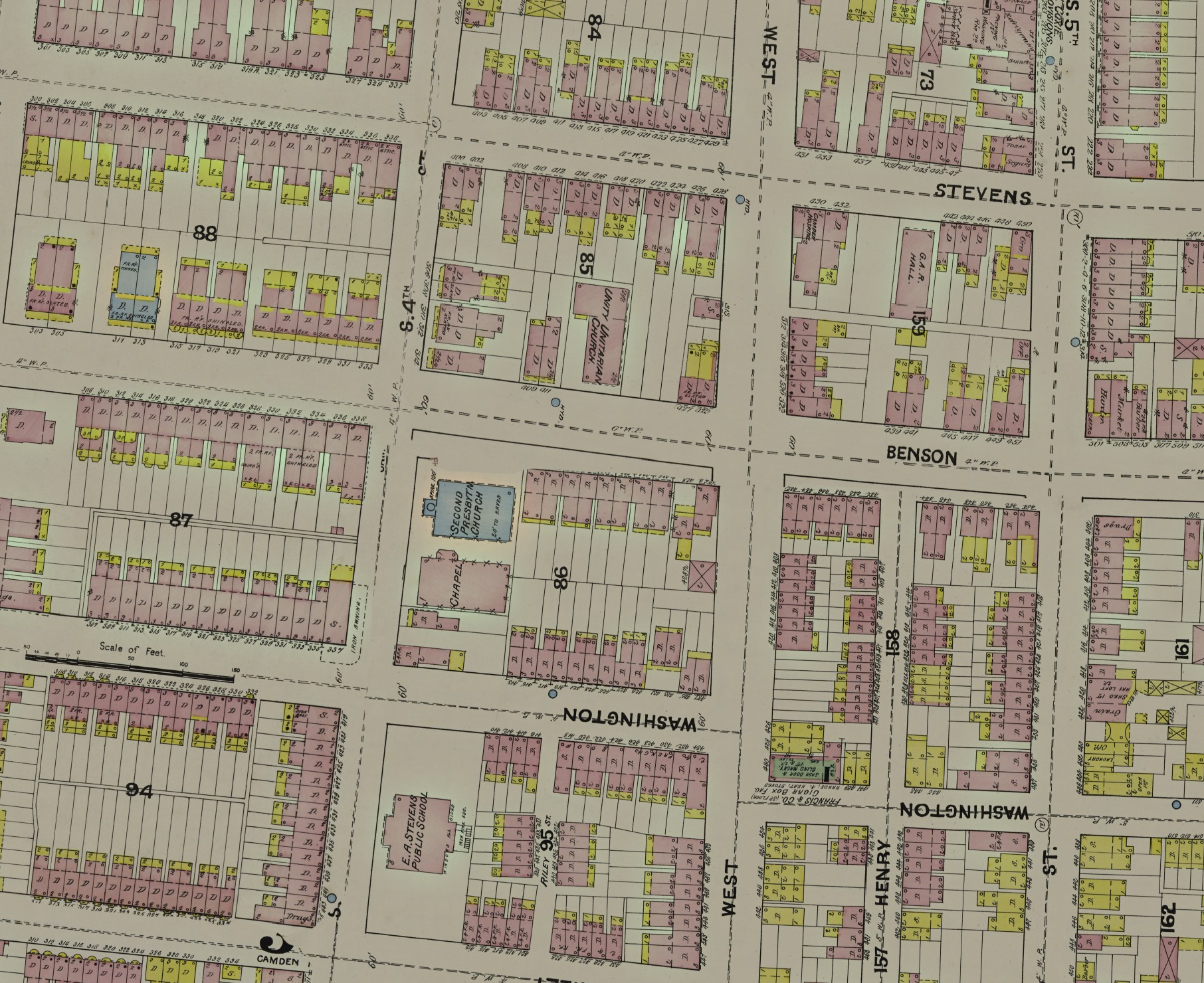
Below (not the static image above!) is the 1891 Sanborn Fire Insurance Map of Camden, New Jersey, laid over a modern map. Use the controls on the map to switch the 1891 map on and off and to change its opacity, so you can compare 1891 Camden with the city today.
Slow to load? This page streams a very large historical map image. Your browser only downloads the parts you are looking at, and it remembers them, so later visits are much faster. The first visit may load slowly, especially on mobile data. The map begins loading when it scrolls into view, and the 1891 layer appears once you zoom in far enough.
What is a Sanborn map?
Sanborn maps are fire insurance maps. The Library of Congress says they were “designed to assist fire insurance agents in determining the degree of hazard associated with a particular property.” The company behind them began in 1867 as the D. A. Sanborn National Insurance Diagram Bureau in New York City. The Library’s collection covers some twelve thousand cities and towns in the United States, Canada and Mexico, from 1867 to 1999.
This map is the 1891 edition for Camden. The Library of Congress holds it as a bound volume of 68 sheets published by the Sanborn Map Company. It also holds an earlier Camden edition, from June 1885, of 23 sheets.
Why Sanborn maps are a gold mine
The Library of Congress calls the Sanborn maps “an unrivaled source of information for their time about the structure and use of buildings in American cities.” For Camden in 1891, that means a lot-by-lot picture of the city. The maps show:
- the size, shape and construction of dwellings, commercial buildings and factories
- fire walls, the locations of windows and doors, sprinkler systems and the types of roofs
- building use, and house and block numbers
- the widths and names of streets, and property boundaries
- the locations of water mains and their dimensions, fire alarm boxes and hydrants
Color carries information too. In the Library of Congress’s description of Sanborn maps, brick and tile are shown in reddish pink, frame (wood) structures in yellow, concrete and cinder block in blue, and metal or iron building materials in gray. The key for reading a volume is usually on its first sheets, so check the original sheets of this one before relying on a color.
One caution from the Library: these maps were made for a specific use, and the needs of the insurance industry dictated what was mapped and how it was portrayed.
About this map
The overlay is a mosaic of the 1891 Sanborn sheets for Camden. Where the sheets do not cover the city, the modern map shows through.
Placement is approximate. The sheets were aligned to the modern map by hand, so features may be off from today's streets by a few meters or more. Additionally, these maps were hand-drawn, so errors in scale may be present.
Source and credit
Credit: Sanborn Fire Insurance Map from Camden, Camden County, New Jersey, 1891. Sanborn Map Company. Library of Congress, Geography and Map Division.
Original sheets: Library of Congress record for the 1891 Camden volume. The Library’s online Sanborn Maps Collection is in the public domain and free to use and reuse. Its credit line is “Library of Congress, Geography and Map Division, Sanborn Maps Collection.”
More: the Library of Congress Sanborn Maps collection, its research guide to Sanborn fire insurance maps, and the June 1885 Camden edition.